- Butane lighters do not work properly above 12,000 feet, and
- When a truck's brakes overheat, the smoke is both dense and vile-smelling.
- When climbing a narrow and twisty mountain road, follow a local. That way, when he brakes, you'll know that something is about to require your attention.
- And the same applies to going down.
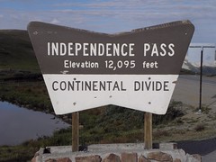
I hate Aspen for precisely the opposite reasons that I hate Las Vegas. Fortunately, on the far side of Aspen lies Independence Pass. At 12,103 feet, this is officially the highest paved pass on the entire continent, of which more anon. A quick photo and down into the relative lowlands for the 122 miles trip to the top of Pikes Peak.
Pikes Peak was only on the list for a laugh as I'd heard that they hadn't paved it all the way to the top. Turns out they have, though they've unpaved a relatively short section at around the halfway point, which was definitely tarmac in 2004. The way not to ascend this mountain is to find yourself stuck behind two smelly and ear-splittingly noisy Harleys, ridden by bastards made of piss. A Harley is incapable of negotiating a tight bend at more than 15 mph, and expecting one to pull over for a mere four-wheeler is like expecting something very unlikely. I chose not to hang around at the 14,110 foot summit in case I met them again on the way down. Instead I was trapped behind a berk in a Chevy SUV who had no notion of engine braking. Which is why he was detained at the mandatory brake temperature check while I went merrily upon my way, before getting stuck behind a similar ignoramus. Bah!

Through Colorado Springs and cut the corner between I-25 and US-50. I had to do a bit of persuasion on the TwatNav to take the scenic route back to Buena Vista via the Arkansas River valley, but it was worth it. In Buena Vista a left turn up a normal residential road leads to the Cottonwood Pass, at 12,119 feet.
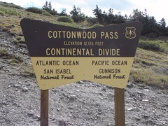 This doesn't count, though, as although it's beautifully surfaced all the way to the top from the eastern side, the other side is unpaved for some miles. Which is doubly interesting when there's a never-ending stream of huge pickups towing bigger campers (and frequently with another trailer tacked on the back of that too) coming the other way. And so to Gunnison, which is nice save for the desk at which I sit being too high.


No comments:
Post a Comment
O hai, spammers!
All comments are moderated so don't bother.
Kthxbai!