Thursday 31 August 2023

Day 8: Williston ND - Great Falls MT

 Montana!  Mountains, right?  Not in the northern bit, no.  Northern Montana is merely a southward extension of the Prairie Provinces Of Canada™ and as such both largely empty and unequivocally drear.  Although the neighbouring bit of North Dakota ent exactly scenic either.  First port of call today was Fort Buford, which has little to commend except a rabbit:

Next door is the Missouri-Yellowstone Confluence Interpretive Center, where a large coach party arrived at the same time as me, thus there was no-one interested in my money to let me into the museumy bits.  Though I did meet a chap who recognised my T-shaped shirt, had heard of Wishbone Ash and wondered whether rock'n'roll's Martin Turner remembered playing his local venue, viz. The Warehouse in New Orleans.  I said I'd ask...  The confluence looks like this:

Yellowstone River dead opposite; Missouri flowing right to left

Just up the road is Fort (checks notes) Union but that didn't look very L&C related either.  And thus ended North Dakota.  First this to see in Montana was also not L&C-related but SCS Software went to all the trouble of modelling the spillway of the Fort Peck Dam for the Montana DLC for American Truck Simulator so it would be foolish to pass up the chance to see it in Real Life.  Even is at this time og year it wasn't likely to have any water in it.

Fort Peck Dam Spillway.  It was Windy.

Head back to US-2 in the town of Glasgow which, according to the wacky cahps at the WaPo, is officially The Middle Of Nowhere.  See https://www.denverpost.com/2018/02/21/where-is-the-middle-of-nowhere/ for details.  Still had a petril station, mind, and one that sold me petril without complaint or requests for a ZIP code.  But it was still a very long way through a lot of this:

Thiseis what passes for Scenery around here

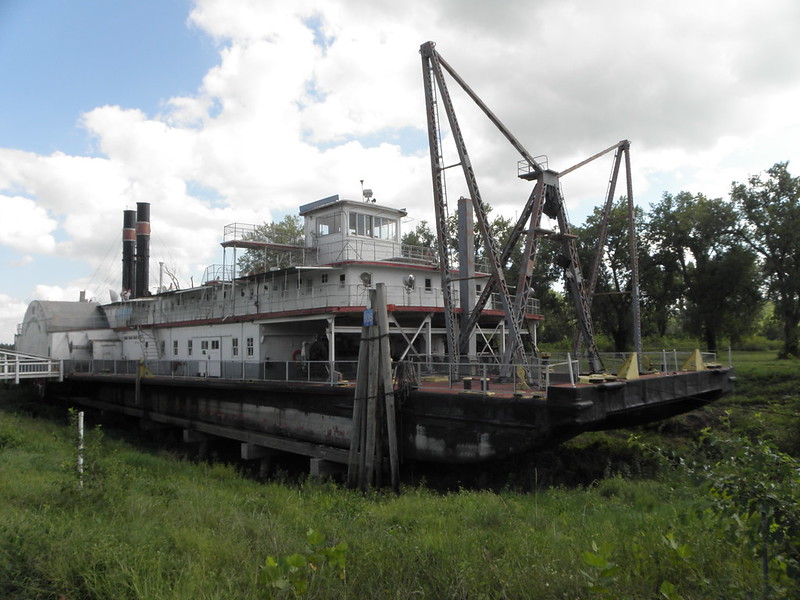
to Fort Benton.  Fort Benton hav a v. interesting history if you are interested in hist. which few boys are.  For a Several of year it was the head of navigation on the Missouri and as such handled goods for not only the surrounding bits of US territory but even Stuffs for destination way north of the 49th Parallel like Exotic Edmonton.  Then the railways came.

The bustling port of Fort Benton, yesterday

Just southwest of here there actually is some scenery but you have to stop and peer over the edge of a cliff to see it.


And soo to Great Falls (pop. > 60,000) where my phone cannot find a network.  Which is seriously fucking annoying when you're trying to book accommodation for tomorrow night at Horseybank plc suddenly decides it wants to use 2FA and send a verification code via txt msg to what is currently naught but a fancy paperweight.  Nice one, giffgaff.  Not.

Wednesday 30 August 2023

Day 7: Bismarck ND - Williston ND

If this post is briefer than you might've hoped, it's because this pikey motel room has a desk but no chair so I'm sitting on the bed with my laptop on the bedside table, which is fucking uncomfortable.

Bismarck, as befits the State Capital of North Dakota, has a State Capitol and outside it is a statue:


Although Sacagawea almost certainly died in 1812 and was thus, unlike Dignity, never photographed, the sculptor based her face on a known descendant so it probably ent a bad likeness.  If only the highways people hadn't been indulging in major 'ole-digging around the I-94 junction...

...then I could have got to New Salem a whole lot quicker.  New Salem has nothing to do with Lewis and Clark but it does have Salem Sue:


She is apparently the world's largest Holstein and frankly I'm surprised that she hasn't been blown up by a raiding party from Wisconsin yet.  This detour is the fault of Danny Guthrie, who passed this way on one of his X-country perambulations a month or two back.  Then it was a retraced bac east along I-94 to Fort Abraham Lincoln in Mandan.  As the name suggests, it was built a Several of decades after the Expedition, tough they did make camp in da hood on both legss of the trip.  It was, however, the lair of celebrated military berk George Armstrong Custer before he went off chasing the Sioux and paying a heavy price for it.

Custer's Last House

There's a nice little museum in the Visitor Center too, though the one at the Interpretive Center a few miles up the road in Washburn is better coz that's nearly all L&C-related.

Hold on! Marge Gunderson? Yaaa!

Lewis versus BEAR

Entry to the museum also gives you entry to the reconstructed Fort Mandan a few miles down the road and right on the river.  The Mandan were one of the local tribes and were already well-known to French and BRITISH traders operating up the Missouri and out of Canada, hence the area was widely regarded as the final frontier of civilisation.  Nevertheless, Fort Mandan, where the expedition spent the winter of 1804-05, was built on the opposite side of the river from the Mandan villages, albeit that this was a lot less of an issue once the river had frozen over.  The proximity was beneficial to both sides since the services of the blacksmith could be traded with the Mandan for food, while Whitey's guns mad hunting bison a lot easier.  Even though the keelboat and a fair few men turned round and hared off downriver at this point, the Fort was not large and was all in all probably a pretty grim place to spend a North Dakota winter.  I expect Seaman was OK, though.

Fort Mandan exterior

Fortunately the gnu was never used

"a dogg of the newfoundland breed"
Seaman has his own overlook on the river bank

North of here is coal-mining country, at least until you get past the Garrison Dam, which holds back the enormous Lake Sakakawea.

Four Bears Memorial Bridge from Crow Flies High overlook

The two main men took different routes on the way back east; Lewis went off to the north to explore the Marias River while Clark cut straight east into the valley of the Yellowstone River, which he followed all the way down to the confluence with the Missouri.  The two parts were reunited not far south of that there bridge, possibly because a buckskin-clad Lewis had been shot in the leg not long before by a near-sighted soldier who mistook him for an elk while the pair were out hunting.

After which point it's gazillions of nodding donkeys pumping oil all the way to Williston.  Tomorrow's entry may be even more concise because, although it's a long way to Great Falls there's not much to see on the way because yet more dams and accompanying lakes.


Tuesday 29 August 2023

Day 6: Chamberlain SD - Bismarck ND

The Highway Authoritahs of the Dakotas have thoughtfully numbered the roads nearest the Mighty Missouri as 1804 on the east side and 1806 on the west.  There are two problems with this.  The first is that, like all TwatNavs, Kate takes a long time to realise that you want to get from A to B on 1804 rather than the logical route which will have traffic.  On it.  We will come to the second problem shortly.  1804 northbound was practically empty all the way to Pierre, wot is the State Capital of South Dakota innit.  As the name suggests, the French got here first, as indeed they did to much of the Missouri valley all the way into present-day North Dakota, which makes the Lewis & Clark Expedition a little less intrepid than might have been suggested.  The Frenchies actually rocked up a what is now Fort Pierre on the west side of the river, where Lewis, Clark et al met with the Teton Sioux, who had a habit of making folks cough up to use their river and who were apparently dissatisfied with the quantity and/or quality of the gifts they were offered.  The language barrier didn't help and things nearly kicked off, but fortunately wiser heads, in the form of Chief Black Buffalo, prevailed and no-one got killed utterly to DETH.  Today the meeting place, at the confluence of the Bad and Missouri rivers, is marked with a rock.  Wowsa!


As usual you are encouraged to go look at the pretty pictures on Flickr, on a Proper Computer rather than a phone or a fondleslab.

Back across the river and continue to follow 1804 north.  Herein the second problem, viz. routes 1804 and 1806 are not continuous.  While they don't just stop in the middle of a field they do terminate and throw the unwary traveller into a bewildering grid of gravel roads.  They had a bunch of signs reading "To 1804" as far as Akaska, at which point I gave up and got back on the tarmac of US-83 and US-12 to Mobridge.  A town whose name must have taken literally seconds to devise.

Bridge(s) on the River MO

Sorry, it was rather hazy today...

If you cross the river here and turn south on 1806 you'll come to a monument to Sacagawea and the grave site of Sitting Bull - seems the old boy was moved here from Fort Yates upriver in 1953.
Sitting Bull wondering what the US Army Corps of Engineers have done to his river


Sacagawea monument

Detail thereof
The bairn is Jean-Baptiste Charbonneau, born in February 1805, who accompanied his parents from Fort Mandan to the Pacific and back.  Clark was much taken with the lad, nicknaming him "Pompey".  I do not think this was due to his being a supporter of Portsmouth FC, not least because they didn't exist in 1805.  He did, however, name a rock formation in the Yellowstone River valley "Pompey's Pillar" when he passed that way on the return journey.  Not to mention carving his name on it - the only physical evidence of the Expedition that still survives.  The great oik.  He did adopt the boy after his mother's death in 1812, thobut.

Sacagawea and her "husband", French trader and interpreter Toussaint Charbonneau, moved to nearby Kenel after their return from the Pacific Coast.  The area is part of the Standing Rock Indian Reservation, site of much pagga during the ultimately unsuccessful protests over the Dakota Access Pipeline a few years back.
Cool water tower, mind...
[...] on February 3, 2017, 39-year-old American Indian activist Chase Iron Eyes and more than 70 peaceably assembled protesters were arrested in a police raid ordered by the Trump administration, on charges of "inciting a riot" which is considered a felony and carries up to 5 years in prison [...]

Who else connected with the Trump regime have we heard apparently inciting a riot, I wonder?

The Standing Rock itself is located in Fort Yates and is, frankly, unimpressive:


though the Reservation's administration building is quite praiseworthy


The reason there are so few sights visited today is because the US Army Corps of Engineers never saw a river without wanting to fuck it up by building a dam or six on it.  Anyway. getting to Bismarck nice and early means I can have an early night too, which hopefully will help send my clod scurrying back whence it came1.

  1. Most likely American Airlines' Boeing 787.

Monday 28 August 2023

Day 5: Council Bluffs IA - Chamberlain SD

 Mucho zagging and, moreover, zigging between states again today viz. Iowa, Nebraska and South Dakota.  First to the Big Lake Park Scenic Overlook on the Iowa side of the river, which offers unparalleled views of, er,


Omaha airport.  To be fair there were some nifty bas-reliefs of Lewis, Clark et al meeting the Native Americans but the light was all wrong so they'd have been invisible.

Swift backtrack and across the river to Omaha NE, where poor Kate the TwatNav was mightily confused by bits of the road system being somewhere other than where she thought they should be.  We did the Riverfront part of Omaha in 2017 and I'd swear blind that none of the fancy Stuffs like the kiddiewinks' playground, the Urban Beach and the gigantic visitor center were there then.  But apparently they've been there 20 years.  So here instead is a picture of a gaily-coloured and nearby water tower:


Followed the Nebraska side of the river for the next Several of miles up to Fort Atkinson.  This didn't appear to have anything going for it that Fort Osage didn't do yesterday except these oddly-hued sqrls:


so I did not linger.  Unlike the sqrls.

"Did someone say 'squirrel'?"
Up the road apiece to Decatur and back across the river to Onawa, where the L&C Museum has a replica of the expedition's keelboat.


Why it's called a "keelboat" is a mystery since among the many things it lacks - 16-litre diesel engine, mirrors on the ceiling, pink champagne on ice ect & moreover, ect - is a keel.  Even without such an impediment the lowly serfs of the expedition spent much of the upstream trip bowhauling this eight-tonne contraption, plus a couple of smaller boats as the current in midstream was too strong for rowing.  The edges of the river were instead beset with hidden sandbars, half-submerged logs and mosquitoes.  When some of the Corps returned to St Louis from Fort Mandan ND in the spring of 1805 the 1500 mile trip back to St Louis took six weeks as opposed to five months going uphill.

Nearby was this amazeballs tree:


but not this:


unless they were hiding behind a tree or disguising themselves as sqrls.

Back to Nebraska for a bit followed by back to Iowa for a bit more, being the Sergeant Floyd Monument:


Sergeant Floyd was the only member of the Expedition to die utterly to DETH, in his case from "bilious colic".  Modern types translate this as "a ruptured appendix", which in them days was a DETH sentence.

The Big List of Places to Go originally had the 3 State Overlook and Spirit Mound in that order but last night someone indicated by means of arrows scrawled on the appropriate bit of paper that they should be swapped over.  A mistake that cost a lot of miles.  Anyway, Spirit Mound is near Vermillion SD and looks like this:


These days you can actually walk to the top, but it's a mile and a half round trip in 30+ Celsius temperatures with no shade or water, so I wimped out.  To prove this is not a stock photo half-inched off of Google here is a Mr Larrington standing next to the info board in the car park:


Pic taken by a fellow L&C Trailer from Georgia1, in case you were wondering.  The navigational cockup meant travelling about twenty miles in the opposite direction and then back, though the views for the 3 State Overlook were worth the effort:

Ponca NE is also home to the first petril station this side of the pond where you fill your motor-car before paying the nice lady or the petril pump.  "We're traditionalists", she said.

"Still," thought Mr Larrington, "at least the route from here to I-90 will take me through Mitchell, the home of Dick's Body Shop so I can get a picture of his famous sign!"  Only problem being that in the last seven years someone has removed the middle panel of the billboard, which is supposed to look like this:

Bah!  If you're wondering why the sudden change of direction away from the Mighty Missouri the answer is that since 1806 a Several of dams have been built in the Dakotas and Montana meaning much of what Lewis and Clark saw will now be under water.  Gavins Point Dam near Yankton being the first and 
Fort Randall Dam the next; the latter backs up the river as Lake Francis Case, on which Chamberlain is situated.  So today, which was supposed to cover 330 miles actually saw 420 because roadworks meant the exit for downtown Chamberlain was closed to westbound traffic, meaning a trip across the bridge and a U-turn.  Natch they didn't mention this until after I'd passed the previous Chamberlain exit.  It also means the rest area is closed which in turned prevented a return visit to Dignity:
Someone showed me a picture and I just laughed
Dignity never been photographed

Bah!

  1. Think Jimmy Carter, not Joseph Stalin

Sunday 27 August 2023

Day 4: Marshall MO - Council Bluffs IA

 Firstly, y'all will no doubt be pleased to learn that I appear only to be suffering from a clod rather than some more advanced form of Lurgi, thought whether the assorted aches besetting this increasingly decrepit body are due to old age, viruses or just sitting in an unfamiliar motor-car remains to be seen.  Still, at least motor-spirit is rather cheaper in this part of the world than it is in California, home of the rob-dogs.  Also I am full of Filthy Pizza, which has improved my mood no end.

As observed yesterday, I orter ov gone to Arrow Rock on the way to Marshall but didn't, so rectified this omission this morning.  Arrow Rock has a population of 56 and I think they were all in church when I got there; also the Visitor Center doesn't open until hours 10:00.  It's pretty nifty inna tourist trap stylee.

Main Street, Arrow Rock

Thence to Fort Osage.  The Corps of Discovery camped on what would become the site of the fort, and Clark returned in 1808 to build it.  In spite of the name it was more a trading post or, as it were, Factory for swapping shoddy tat for furs collected by the Native Americans.

Shoddy tat store, Fort Osage

Fort.  Missouri.  Sunday.

The War of 1812 didn't help, because us perfidious BRITISH told the locals that they could trade with the Hudson's Bay Company and get much better quality BRITISH Stuffs and if you wouldn't mind burning down a few American outposts that's be just dandy.  Eventually Big Bizness put the Federal Government's trading policies out of their misery and the place was abandoned and recycled by the local Eurotrash.  The current version was built after WW2 and is quite a lot smaller than the original, on account of the burghers of Sibley hauling goods up from the river with oxen, leaving a bloody great 'ole in the middle of what used to be the fort.


The urban sprawl of Kansas City next, as they have a nifty statue of divers members of the Expedition up on the hill overlooking the confluence of the Kansas and Missouri Rivers.  This side features Lewis, Clark and Sacagawea:

But where did Clark get that smartphone?

while t'other is York and Seaman.

York was Clark's slave and rather hoped be be freed once the journey was over.  While historians are agreed that this didn't happen immediately the party returned to St Louis, opinions vary as to what actually did happen to him.  See https://en.wikipedia.org/wiki/York_(explorer)

Crossed the river into Kansas, specifically Atchison.  Being the birthplace of pioneering aviatrix Amelia Earhart, whose disappearance during a round the world flight in 1937 led to numerous conspiracy theories and at least one concept album1.

Just up the road is Independence Creek, so named because this was where the Corps camped on the 4th of July 1804.  Not much there unless I didn't look in the right place.

If you carry on following the river northwards Kansas turns into Nebraska without much ceremony and in Brownville lies this:

The Captain Meriwether Lewis

Broadcaster Jack de Manio once said of Glenda Jackson that "she had a face that could launch a thousand dredgers" but poor Lewis only got the one.  Also it took until 1931 to launch it.  On the other side of the river lies Missouri again but after a short blast up I-29 it turns into Iowa thus making four states today.

Also I really should have applied the old sun-schlog today as my fishbelly-white appendages have turned quite red.  Ooops.

  1. "In Search Of Amelia Earhart", Plainsong, 1972

Saturday 26 August 2023

Day 3: Alton IL - Marshall MO

I feel like DETH and really don't want to do anything except go to sleep.  Even though there's pizza within 200 yards.

Six hours of fever dreams later...  OK, where were we?  Answer: in the rain in Alton.  The Beeb's "thundery showers" turned out to be nothing of the sort but rather downpours of the torrential variety which continued with variations in intensity until mid-afternoon.  First port of call: the Gateway Arch in St Louis.

A The Gateway Arch, yesterday

Designed by Eero Saarinenen, built in the mid-1960s and intended to commemorate USAnia's westward expansion, which is all very laudable unless you happened to live there already.  You can exchange Money for a ticket to travel to the top, 630 feet up, where on a clear day you can see for miles. And miles and miles and miles and ["Shut up, Daltrey!" - Ed.]  Today you couldn't, and they really need windscreen wipers on the slit-like windows coz I couldn't see much at all chiz.

Crap view of some of the bridges across the Mighty Mississippi

Old Court House across the road from the Arch, currently closed for renovation

Next stop St Charles, where there is a Lewis & Clark Museum & Boathouse.  The latter contains replicas of the divers boats used by the intrepid explorers but they were safely locked up in their cage today which precluded photography.

Boat House & Museum

Seaman.  Didn't even have a coin slot in his head chiz.

The museum has a replica of Seaman, Lewis' Newfoundland doggo, outside pleading with big puppy eyes to spend five bucks, see Stuffs and watch a slick video, with Jeff Bridges voiceover! - reconstructing some of the highlights of the expedition, such as avoiding rucks with the locals, nearly starving utterly to DETH crossing the mountains in Montana and Idaho and the sort of coincidence that Hollywood would have dismissed as too improbable, viz. teenage Shoshone woman and interpreter Sacagawea1 running into a party not only from her own tribe but actually led by her brother just when the Expedition needed to blag horses for the crossing of the mountains.

Now you'll remember, iffen you've seen the fillum "The Blues Brothers", the song "She Caught The Katy".  This is the Katy today:

The mule she left me to ride wasn't around today...
A 237-mile rails-to-trails project stretching most of the way across Missouri using the route of the Missouri, Kansas and Texas Railroad - later shortened to "the KT".  Y'all can die happy knowing that.

Next stop Hermann which, as the name might suggest, was founded by German settlers in 1837 and is home to a thriving viniculture, a shop selling a gazillion varieties of sausage (natch) and some cool buses.

Bus. Hermann. Saturday.
Thence to Jefferson City, state capital of Missouri.  There's supposed to be some L&C-related Stuffs around the Capitol building, which is a jolly impressive pile, but I couldn't find them and by now was feeling disinclined to spend much time looking for them.

Missouri State Capitol, Jefferson City

I was supposed to visit Boonville and Arrow Rock too, but they can wait until tomorrow today.  Hopefully normal Mr Larrington will have resumed by then, coz I don't fancy stopping another night here when there are Sights to be Seen.

  1. Spelling of her name varies but this seems to be the most common so I'll stick with it.